Hurricane Lowell makes final turn toward Hawaii as islands brace for impacts

Hurricane Lowell Turns Toward Hawaii
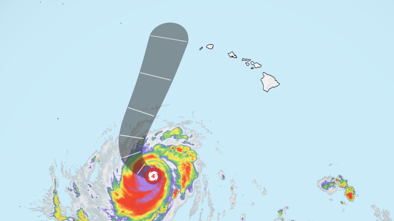
Healfromzero.com – After days of being pinned south of the Hawaiian chain by a stubborn upper-level ridge, Hurricane Lowell makes final turn toward the islands, executing a sharp rightward swing that will carry its outer bands within striking distance of the western islands. Tropical-storm warnings and hurricane watches now cover Kauai and Niihau, marking the third consecutive storm in barely four weeks to aim at the state — a streak amplified by El Niño conditions pushing Pacific basin activity well beyond seasonal norms.
Storm Status and Projected Track
The National Hurricane Center classifies the system as a Category 3 hurricane with sustained winds of 120 mph, moving northward at roughly 9 mph. Lowell has oscillated between categories during its transit, a pattern consistent with the internal cycling typical of major hurricanes. Forecasters project the storm will weaken to near Category 2 intensity by the time it reaches closest approach.
The projected center track places the storm approximately 100 miles west of Niihau and 150 miles west of Kauai from late Monday night through Tuesday morning local time. While that spacing keeps the core’s most violent winds offshore, the islands will still experience tropical-storm-force gusts exceeding 39 mph from late Monday into Tuesday. Mountain ridges and steep slopes across the western islands can amplify those gusts to hurricane-force levels as terrain accelerates airflow through narrow valleys and over exposed summits.
Emergency Declarations and Island Preparations
Hawaii Governor Josh Green declared a state of emergency across the entire state, a move that unlocks federal resources and authorizes activation of Hawaii National Guard units. Six high-water vehicles are being staged on Kauai to handle anticipated flooding on low-lying roads.
Kauai County moved to close every park and campground on the island and to open five designated refuge areas beginning Sunday. Mayor Derek S.K. Kawakami framed the decision in a public statement:
“Closing our parks and opening refuge areas is not a decision we make lightly, but it is the right call with a storm of this strength still turning toward us.”
The Kauai Emergency Management Agency advised residents to remain indoors and off roadways as conditions deteriorate, to fill fuel tanks, charge electronic devices, and stock sufficient water and food supplies. In Lihue — a town of roughly 8,000 that hosts the island’s primary airport — supermarket shelves were visibly thinning as residents stockpiled essentials ahead of the storm’s arrival.
“We’ll lose some power, probably have some trees, a bunch of tree limbs coming down,” real estate agent Lori Benkert said. “Everybody is probably going just to hunker down.”
The Meteorological Setup Behind the Turn
For several days, the storm had been trapped beneath a weak upper-level high-pressure zone that functioned as an atmospheric barrier, channeling it westward and keeping it south of the islands. That configuration began to collapse over the weekend when a trough of cold air descended from the north Pacific and interacted with a nearby low-pressure area. Once the ridge weakened sufficiently, the system shed its westward constraint and began swinging northward in a dramatic right turn that will carry it along the western edge of the Hawaiian chain.
The geometry of this turn draws an uncomfortable parallel to Hurricane Iniki of 1992, which struck Kauai as a Category 4 hurricane and remains the most destructive storm in the state’s recorded history. The critical difference this time is distance: forecasters expect the storm to remain far enough offshore to avoid a direct landfall, sparing the islands the catastrophic wind damage Iniki inflicted.
Surf, Rain, and Flooding Threats
Even without a direct hit, the storm’s energy is already reshaping coastal conditions. Swells generated by the system are producing hazardous surf statewide, with conditions expected to escalate sharply on Monday. A high surf warning remains in effect through early Tuesday for south-facing shores of Oahu, Maui County, and the Big Island. The National Weather Service in Honolulu projects waves of 7 to 10 feet building rapidly Monday afternoon and evening, reaching 12 to 20 feet on Oahu and 12 to 16 feet across Maui County and the Big Island. Those swells can sweep across beaches and low-lying coastal zones, threatening roads, seawalls, and other infrastructure. Powerful rip currents and large breaking waves at beaches and harbor entrances add further danger for swimmers and small craft.
Rainfall will be the storm’s most widespread impact. Kauai and Niihau face 6 to 10 inches of rain, with isolated heavier totals possible where terrain forces sustained upslope flow. Prolonged downpours of this magnitude raise the risk of flash flooding in stream channels, washouts on rural roads, and saturated-ground failures on steep slopes.
Frequently Asked Questions
When will the storm be closest to the islands? Forecasters project the center will pass roughly 100 miles west of Niihau and 150 miles west of Kauai from late Monday night through Tuesday morning local time. Tropical-storm-force gusts exceeding 39 mph are expected during that window.
Do I need to evacuate my home on Kauai or Niihau? Kauai County has not issued a mandatory evacuation. However, the county has closed all parks and campgrounds and opened five refuge areas beginning Sunday. Residents in low-lying or flood-prone zones should monitor local advisories and be prepared to move to a refuge if directed.
Is it safe to go to the beach this weekend? No. A high surf warning is in effect through early Tuesday for south-facing shores of Oahu, Maui County, and the Big Island. Waves of 12 to 20 feet are projected, with powerful rip currents and large breaking waves at beaches and harbor entrances. Swimmers and small craft should stay out of the water.
How does this storm compare to Hurricane Iniki? Iniki (1992) made direct landfall on Kauai as a Category 4 hurricane and remains the state’s most destructive storm on record. This system is expected to remain well offshore, so while wind and rain impacts will be significant, the catastrophic direct-hit damage of Iniki is not anticipated.
What should I do right now if I live on the western islands? Fill fuel tanks, charge devices, and stock at least three days of water and non-perishable food. Know the location of the nearest designated refuge area. Stay indoors and off roadways once conditions deteriorate. Monitor the National Weather Service in Honolulu and Kauai Emergency Management Agency updates for real-time advisories.