
Unusually strong summer storm puts New York City at the center of a Northeast flash flood threat
Unusually Strong Summer Storm Puts NYC on Alert
Northeast Faces Major Flash Flood Threat
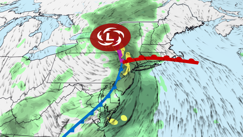
Healfromzero.com – Unusually strong summer storm puts New York City at the center of a growing concern as meteorologists warn of potentially dangerous flash flooding across the northeastern United States. This powerful weather system is expected to deliver more than a month’s worth of rainfall to certain areas before Tuesday night ends. Communities stretching from Baltimore and Philadelphia through the tri-state region into southwestern New England—home to over 35 million people—have received flood watch advisories.
Weather models predict rainfall totals between three and five inches across the affected region. Some localized areas could see up to seven inches of precipitation, particularly in zones running from northeastern New Jersey through the Lower Hudson Valley and into southwestern Connecticut. This upper range surpasses New York City’s typical July average of 4.60 inches, making this an exceptional weather event for the summer season.
Urban Drainage Systems Under Pressure
“The primary danger comes from rain falling at rates of one to three inches per hour in densely populated urban centers,” said a National Weather Service meteorologist.
Weather activity continued throughout Tuesday morning, extending from central New York down to West Virginia. Conditions along the Interstate 95 corridor are expected to worsen significantly during late afternoon hours. The most dangerous period stretches through the evening into Wednesday morning, with rainfall intensity posing greater risk than total accumulation alone.
Such heavy downpours can quickly overwhelm existing stormwater drainage networks. New York City’s infrastructure handles rainfall up to 1.75 inches per hour, but this threshold is being exceeded more frequently. Climate researchers link this pattern to global warming, which allows warmer air to hold substantially more moisture. When weather systems extract this accumulated humidity—similar to wringing out a wet sponge—the outcome is often intense, localized downpours that surprise communities.
Monday’s Storm Preview Signals Bigger Event
Monday offered residents a warning of what Tuesday’s system would bring. Northern New Jersey saw isolated but powerful storms develop ahead of the main weather front. Radar data showed a slow-moving thunderstorm dropped more than three inches of rain near Glen Rock and Ridgewood, causing significant flooding in parts of both Bergen and Passaic counties. Video footage from Glen Rock captured a BMW nearly completely submerged in floodwaters. Two passengers escaped the vehicle before emergency crews arrived, though water depths initially prevented tow trucks from reaching the stranded car.
Multiple water rescue operations were conducted throughout Glen Rock, Hawthorne, and Fair Lawn as floodwaters surged through residential streets.
Climate Factors Drive Unusual Storm Intensity
The storm’s expected Wednesday intensity—when it slows and strengthens—will rival systems typically seen during colder seasons rather than late July. Such powerful configurations are uncommon in summer because the jet stream generally provides less energetic support for storm development during warmer months. At the same time, this weather pattern is drawing on enhanced, moisture-laden atmospheric rivers from both the Atlantic Ocean and the Gulf of Mexico.
The water vapor content within this air mass will exceed average levels even for midsummer’s notoriously humid conditions. These contrasting atmospheric forces will collide, generating multiple cycles of heavy rainfall and thunderstorm activity across the northeastern corridor. The New York tri-state region, extending from northern New Jersey through western Connecticut, faces the highest probability of flooding rainfall during Tuesday and Tuesday night.
What Residents Should Know
While the tri-state region faces the greatest threat, most other northeastern territories will experience some level of impact. The most intense storms are expected to begin by late afternoon and continue through overnight hours. Certain metropolitan areas will see multiple precipitation cycles, though exact timing for each wave remains difficult to predict. Urban neighborhoods and zones with inadequate drainage systems face the highest risk of flash flooding.
Frequently Asked Questions
When is the peak flood risk period?
The highest flood risk occurs during Tuesday afternoon through Wednesday morning, with the most dangerous conditions expected between 4 PM and midnight on Tuesday.
How much rainfall is expected in New York City?
Forecast models predict three to five inches of rain for most of the city, with some areas potentially receiving up to seven inches—exceeding the typical July average of 4.60 inches.
Why are summer storms becoming more intense?
Climate scientists attribute increasing storm intensity to global warming, which allows warmer atmospheric layers to retain substantially more moisture, leading to heavier precipitation when weather systems extract this humidity.
Which areas are most vulnerable to flash flooding?
The New York tri-state region faces the highest probability, particularly urban neighborhoods and zones with inadequate drainage systems in northern New Jersey, the Lower Hudson Valley, and southwestern Connecticut.