Tropical storm warning issued in Louisiana for major flood threat
Tropical Storm Warning Issued in Louisiana for Major Flood Threat
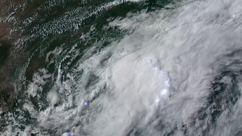
Tropical storm warning issued in Louisiana – A warning has been raised for parts of Louisiana’s coastline as a weather system approaches, potentially evolving into a short-lived tropical storm. The National Hurricane Center (NHC) has designated this system as Potential Tropical Cyclone One, a classification used for storms that have not yet fully formed but may bring tropical conditions to land within 72 hours. This label underscores the likelihood of significant rainfall and flooding impacts across the Gulf Coast region. The system is currently centered approximately 15 miles south-southeast of Corpus Christi, Texas, as of 7 p.m. CT. Its trajectory suggests it will soon transition into Tropical Storm Arthur by early Wednesday morning, with further movement inland expected to affect extreme east Texas or southwest Louisiana by late Wednesday or early Thursday.
Heavy Rainfall and Flood Risks
The primary concern for residents in the Gulf states is the intense rainfall forecasted from this system. Even if it doesn’t officially become a tropical storm, the moisture it carries is already causing widespread flooding. In Texas, at least one fatality has been reported, with a woman being swept away by floodwater in Bandera County on Monday. According to the sheriff’s office, she called 911 and described being “floating downstream at a high rate of speed and unable to exit her vehicle.” Swift water rescue teams were deployed after losing contact with her, and her vehicle was later found several miles downstream, completely submerged.
“This just dumped a tremendous amount of rain,” said Joshua Abercrombie, chief of the Picayune Fire Department, referring to the sudden deluge that hit parts of Mississippi. “We’re not used to flooding in the areas we got it in.”
The NHC warns that tropical-storm-force winds of 40 mph or greater will affect the warning area from Sabine Pass to Morgan City, Louisiana. However, the more immediate danger lies in the heavy rainfall, which is expected to produce rates of 3 to 4 inches per hour in some regions. Over the next few days, additional 4 to 8 inches of rain could fall across southern Louisiana, central and southern Mississippi, and western Florida. In certain spots, rainfall totals could reach up to a foot, exacerbating existing flood conditions.
Regional Impact and Preparedness
Flood watches have been issued for over 27 million people spanning from South Texas to central and southern Mississippi. Cities such as Brownsville and Houston, Texas; Lake Charles, Louisiana; Jackson, Mississippi; and Atlanta, Georgia, are among those at risk of life-threatening flash floods. The Weather Prediction Center has elevated the flood threat level to 3 out of 4 for parts of Texas, Louisiana, Mississippi, and Alabama, with the danger persisting through Thursday. This includes areas where earlier rainfall has already contributed to waterlogged streets and infrastructure.
Since Sunday afternoon, the National Weather Service has logged over 120 flood reports across the affected regions. The system’s moisture colliding with a stalled front has led to prolonged heavy downpours, creating a dangerous scenario for low-lying areas. In the greater Houston metro area, street flooding in Montgomery County on Tuesday forced several vehicles to be stranded and resulted in at least 10 road closures. Similarly, in Travis County, about 80 low water crossings were flooded on Monday, highlighting the vulnerability of the region’s road networks.
The ongoing rainfall has also impacted communities in Mississippi, where homes and buildings were submerged in Picayune. Fire crews rescued a family, including an infant, from a house with water up to the knees. Meanwhile, floodwater reached waist-deep levels on roads outside the home, creating challenges for emergency responders. Despite the severity, no injuries were reported in the city during these incidents.
Residents in Shreveport, Louisiana, faced similar disruptions on Monday, with floodwater entering commercial buildings and a technical college. The Caddo Parish Sheriff’s Office received 52 water rescue calls within a six-hour window, though the exact number of required interventions remains unclear. These incidents underscore the scale of the challenge facing authorities in managing the crisis.
State Response and Disaster Declaration
In response to the escalating situation, Texas Governor Greg Abbott has declared a state of disaster for 101 counties, activating additional emergency resources. This decision reflects the urgent need to coordinate relief efforts and support communities affected by the flooding. The governor’s action is likely to aid in mobilizing aid, securing shelters, and providing financial assistance for recovery.
Meanwhile, local officials are working to assess the damage and ensure public safety. In Williamson County, drivers stranded in floodwater have been assisted since Monday, with ongoing reports of vehicles being swept away. The situation has forced authorities to prioritize rescue operations and maintain communication with affected residents. As the storm continues its path, the focus remains on monitoring rainfall trends and updating flood warnings to prepare for potential secondary impacts.
With the system set to bring prolonged heavy rain, the potential for further flooding is high. This includes areas that have already experienced significant precipitation, such as parts of South Texas and Louisiana, where some locations have seen 4 to 8 inches of rain. The NHC emphasizes that the threat will persist through Thursday, requiring sustained vigilance from both residents and emergency teams. As the storm moves inland, its combination of strong winds and torrential rain could lead to widespread disruptions, affecting transportation, utilities, and daily life.
Residents are advised to stay informed through local weather updates and to take precautions such as avoiding flooded roads, securing property, and preparing for possible evacuations. The situation serves as a reminder of the power of tropical systems, even before they fully develop, to create life-threatening conditions in the Gulf Coast region. With the Level 3 threat designation, the NHC and local authorities are closely tracking the system to provide timely warnings and support to those in need.